
Super Deals
Access Code Required
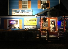
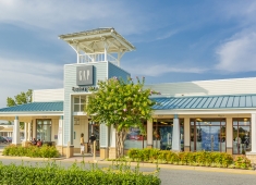
Participating Merchants


Trails
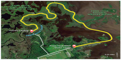
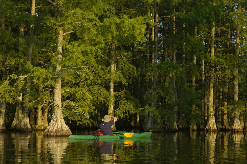
Prime Hook Visitors Center to Foord’s Landing Trail
Local information
Fees & Parking: Prime Hook National Wildlife Refuge does not charge an entrance fee; however you may obtain Federal Duck Stamps or any of the three Department of the Interior passes (America the Beautiful, Senior, and Access passes) during administrative office hours.
Tides: The nearest tide tables are for Lewes, Breakwater Harbor.
Weather: Check the forecast for Milton, DE.
Trail Towns: Milton and Lewes
eBird checklists: Prime Hook NWR Headquarters Area and Foord’s Landing Road
Paddler’s notes: For more information about Prime Hook NWR, please visit the refuge website. They offer a Prime Hook NWR Canoe Trail.
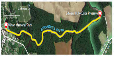
Milton to McCabe Preserve Trail
Local information
Fees & Parking: There is no fee to launch from Milton Memorial Park. Please do not park you vehicle in a space designated for a a vehicle with a boat trailer.
Tides: The nearest tide tables are for Lewes, Breakwater Harbor.
Weather: Check the forecast for Milton, DE.
Trail Towns: Milton
eBird checklists: McCabe Nature Preserve
Paddlers’ notes: The recommended paddle is from Milton Memorial Park to the Edward H. McCabe Nature Preserve and back to Milton. There is a floating dock and picnic area at the McCabe Preserve. Please abide by the preserve rules when visiting.
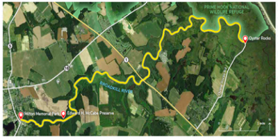
Milton to Oyster Rocks Trail
Local information
Fees & Parking: There is no fee to launch from Milton Memorial Park or Oyster Rocks. Please do not park your vehicle in a space designated for a vehicle with a boat trailer at Memorial Park. Please park safely along the shoulder near the end of Oyster Rocks Road, but stay on the asphalt (the edges are mostly salt marsh mud, and you can get stuck!).
Tides: The nearest tide tables are for Lewes, Breakwater Harbor.
Weather: Check the forecast for Milton, DE.
Trail Towns: Milton and Lewes
eBird checklists: McCabe Nature Preserve and Oyster Rocks Road
Paddlers’ notes: The Broadkill River changes dramatically from Milton to Oyster Rocks. Near Milton, the river meanders through forest before it transitions to farmland and salt marsh towards Oyster Rocks. It is recommended that you paddle with the tide on this trail. During an outgoing tide, depart from Milton. During an incoming tide, depart from Oyster Rocks. If you paddle the full trail, make certain to stop for a break at the Edward H. McCabe Nature Preserve. There is a floating dock and picnic area at the McCabe Preserve. Please abide by the preserve rules when visiting.
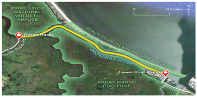
Oyster Rocks to Lewes Boat Ramp Trail
Local information
Fees & Parking: There is no fee to launch from Oyster Rocks or the Lewes Boat Ramp. Please park safely along the shoulder near the end of Oyster Rocks Road, but stay on the asphalt (the edges are mostly salt marsh mud, and you can get stuck!). Please do not park you vehicle in a space designated for a vehicle with a boat trailer at the Lewes Boat Ramp. The launch area can be very busy during peak fishing season (usually April-October), with most traffic in early morning and mid-afternoon.
Tides: The nearest tide tables are for Lewes, Breakwater Harbor.
Weather: Check the forecast for Lewes, DE.
Trail Towns: Lewes
eBird checklists: Oyster Rocks Road and Roosevelt Inlet
Paddlers’ notes: It is recommended to paddle on an outgoing tide from Oyster Rocks to Lewes. At the start, the Broadkill River skirts along Prime Hook National Wildlife Refuge before it courses between the Great Marsh Preserve and Beach Plum Island Nature Preserve.
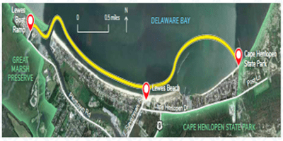
Cape Henlopen State Park to Lewes Boat Ramp Trail
Local information
Fees & Parking: There is no fee to launch from the Lewes Boat Ramp. Please do not park your vehicle in a space designated for a vehicle with a boat trailer at the Lewes Boat Ramp. The launch area can be very busy during peak fishing season (usually April-October), with the most traffic in the early morning and mid-afternoon. There is a daily park entry fee for Cape Henlopen State Park, and costs vary for vehicles registered in Delaware and out-of-state. To avoid the daily fee, you can purchase an annual Delaware State Parks pass. If you choose to launch from Lewes Beach, parking meters are in operation seasonally.
Tides: The nearest tide tables are for Lewes, Breakwater Harbor.
Weather: Check the forecast for Lewes, DE.
Trail Towns: Lewes
eBird checklists: Roosevelt Inlet and Cape Henlopen State Park Fishing Pier
Paddlers’ notes: It is recommended to paddle on an incoming tide if you paddle from Cape Henlopen State Park to the Lewes Boat Ramp. Please paddle a safe distance around the Cape May-Lewes Ferry Terminal. On your way, you can stop for a beach break at Lewes Beach.
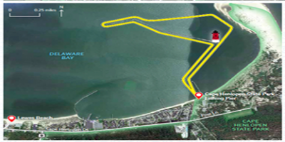
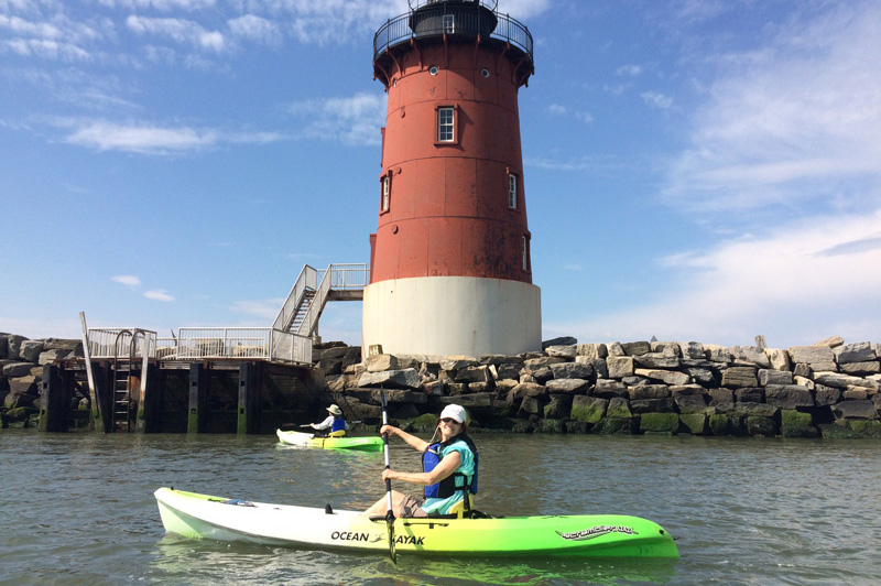
Cape Henlopen and Lighthouse Loop
Local information
Fees & Parking: There is no fee to launch from the Lewes Boat Ramp. Please do not park your vehicle in a space designated for a vehicle with a boat trailer at the Lewes Boat Ramp. The launch area can be very busy during peak fishing season (usually April-October), with the most traffic in the early morning and mid-afternoon. There is a daily park entry fee for Cape Henlopen State Park, and costs vary for vehicles registered in Delaware and out-of-state. To avoid the daily fee, you can purchase an annual Delaware State Parks pass. If you choose to launch from Lewes Beach, parking meters are in operation seasonally.
Tides: The nearest tide tables are for Lewes, Breakwater Harbor.
Weather: Check the forecast for Lewes, DE.
Trail Towns: Lewes
eBird checklists: Roosevelt Inlet and Cape Henlopen State Park Fishing Pier
Paddlers’ notes: It is recommended to paddle on an incoming tide if you paddle from Cape Henlopen State Park to the Lewes Boat Ramp. Please paddle a safe distance around the Cape May-Lewes Ferry Terminal. On your way, you can stop for a beach break at Lewes Beach. For the Cape Henlopen and Lighthouse loop, you can paddle out to the East End Lighthouse and explore life on the rocks along the inner breakwater.
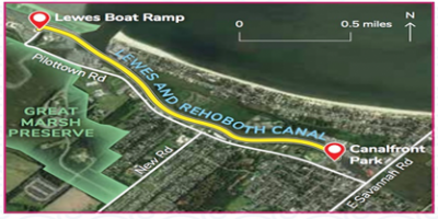
Lewes Boat Ramp to Canalfront Park Trail
Local information
Fees & Parking: There is no fee to launch from the Lewes Boat Ramp. Please do not park your vehicle in a space designated for a vehicle with a boat trailer at the Lewes Boat Ramp. The launch area can be very busy during peak fishing season (usually April-October), with the most traffic in the early morning and mid-afternoon. If you choose to launch from Canalfront Park, parking meters are in operation seasonally. There is a daily park entry fee for Tower Road (part of Delaware Seashore State Park), and costs vary for vehicles registered in Delaware and out-of-state. To avoid the daily fee, you can purchase an annual Delaware State Parks pass.
Tides: The nearest tide tables are for Lewes, Breakwater Harbor for Lewes Boat Ramp and Canalfront Park, and Indian River Inlet for Tower Road.
Weather: Check the forecast for Lewes, DE, and Rehoboth Beach, DE.
Trail Towns: Lewes, Rehoboth Beach, and Dewey Beach
eBird checklists: Roosevelt Inlet and Tower Road
Paddlers’ notes: Be mindful of the tides when paddling close to the Roosevelt Inlet near the Lewes Boat Ramp and near the narrow opening in the canal just north of the Route 9 bridge south of Lewes. You may experience heavy currents at peak high and low tides. When paddling near Canalfront Park, be sure to check out the large red boat known as the Lightship Overfalls. Most of the Lewes-Rehoboth Canal runs through the marshes of Cape Henlopen State Park before coming to Henlopen Acres and Rehoboth Beach. A canoe/kayak launch at Grove Park near the Rehoboth Beach Museum has been constructed and is slated to open soon. Before you reach the beach at Tower Road, you will pass by the Thompson Island Preserve. If you want a launch site in Rehoboth Bay other than Tower Road, you can paddle to Mulberry Knoll at the mouth of Love Creek.
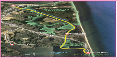
Canalfront Park to Tower Road Trail
Local information
Fees & Parking: There is no fee to launch from the Lewes Boat Ramp. Please do not park your vehicle in a space designated for a vehicle with a boat trailer at the Lewes Boat Ramp. The launch area can be very busy during peak fishing season (usually April-October), with the most traffic in the early morning and mid-afternoon. If you choose to launch from Canalfront Park, parking meters are in operation seasonally. There is a daily park entry fee for Tower Road (part of Delaware Seashore State Park), and costs vary for vehicles registered in Delaware and out-of-state. To avoid the daily fee, you can purchase an annual Delaware State Parks pass.
Tides: The nearest tide tables are for Lewes, Breakwater Harbor for Lewes Boat Ramp and Canalfront Park, and Indian River Inlet for Tower Road.
Weather: Check the forecast for Lewes, DE, and Rehoboth Beach, DE.
Trail Towns: Lewes, Rehoboth Beach, and Dewey Beach
eBird checklists: Roosevelt Inlet and Tower Road
Paddlers’ notes: Be mindful of the tides when paddling close to the Roosevelt Inlet near the Lewes Boat Ramp and near the narrow opening in the canal just north of the Route 9 bridge south of Lewes. You may experience heavy currents at peak high and low tides. When paddling near Canalfront Park, be sure to check out the large red boat known as the Lightship Overfalls. Most of the Lewes-Rehoboth Canal runs through the marshes of Cape Henlopen State Park before coming to Henlopen Acres and Rehoboth Beach. A canoe/kayak launch at Grove Park near the Rehoboth Beach Museum has been constructed and is slated to open soon. Before you reach the beach at Tower Road, you will pass by the Thompson Island Preserve. If you want a launch site in Rehoboth Bay other than Tower Road, you can paddle to Mulberry Knoll at the mouth of Love Creek.
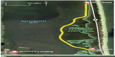
New Road to Savages Ditch Trail
Local information
Fees & Parking: There are daily park entry fees for New Road, Savages Ditch, and the Indian River Inlet Marina. All three launch sites are part of Delaware Seashore State Park, and costs vary for vehicles registered in Delaware and out-of-state. To avoid the daily fee, you can purchase an annual Delaware State Parks pass.
Tides: The nearest tide tables are for Indian River Inlet.
Weather: Check the forecast for Rehoboth Beach, DE.
Trail Towns: Rehoboth Beach and Dewey Beach
eBird checklists: Tower Road, Savages Ditch, and Burton Island
Paddlers’ notes: Be mindful of the tides when paddling close to the Indian River Inlet. Enjoy a post-paddle hike at the Burton Island Nature Preserve, which is part of Delaware Seashore State Park. Access to Burton Island is by causeway at the north end of the Indian River Marina near the launch site. If you want a different launch site in southern Rehoboth Bay, you can paddle to Massey’s Landing.
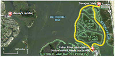
Savages Ditch to Indian River Inlet Marina (Burton Island) Launch
Local information
Fees & Parking: There are daily park entry fees for New Road, Savages Ditch, and the Indian River Inlet Marina. All three launch sites are part of Delaware Seashore State Park, and costs vary for vehicles registered in Delaware and out-of-state. To avoid the daily fee, you can purchase an annual Delaware State Parks pass.
Tides: The nearest tide tables are for Indian River Inlet.
Weather: Check the forecast for Rehoboth Beach, DE.
Trail Towns: Rehoboth Beach and Dewey Beach
eBird checklists: Tower Road, Savages Ditch, and Burton Island
Paddlers’ notes: Be mindful of the tides when paddling close to the Indian River Inlet. Enjoy a post-paddle hike at the Burton Island Nature Preserve, which is part of Delaware Seashore State Park. Access to Burton Island is by causeway at the north end of the Indian River Marina near the launch site. If you want a different launch site in southern Rehoboth Bay, you can paddle to Massey’s Landing.
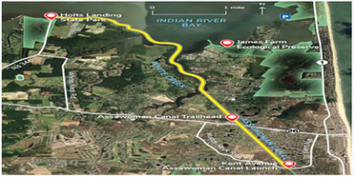
Holts Landing to Kent Avenue Trail
Local information
Fees & Parking: There are daily park entry fees for Holts Landing State Park. Costs vary for vehicles registered in Delaware and out-of-state. To avoid the daily fee, you can purchase an annual Delaware State Parks pass. There are no parking fees for the James Farm Ecological Preserve or the Kent Avenue Assawoman Canal Launch.
Tides: The nearest tide tables are for Indian River Inlet.
Weather: Check the forecast for Bethany Beach, DE.
Trail Towns: Ocean View and Bethany Beach
eBird checklists: Holts Landing State Park and James Farm Ecological Preserve
Paddlers’ notes: Be mindful of the tides if you choose to paddle north of this zone, which is close to the Indian River Inlet. Enjoy a post-paddle hike at the James Farm Ecological Preserve, which is managed by the Delaware Center for the Inland Bays. The James Farm has a wonderful beach for launching a kayak, but the parking area for the preserve is a long hike to the water.
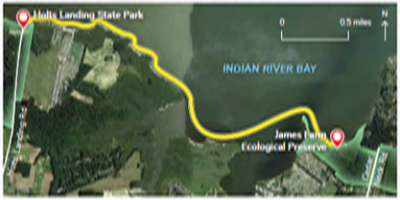
Holts Landing to James Farm Ecological Preserve Trail
Local information
Fees & Parking: There are daily park entry fees for Holts Landing State Park. Costs vary for vehicles registered in Delaware and out-of-state. To avoid the daily fee, you can purchase an annual Delaware State Parks pass. There are no parking fees for the James Farm Ecological Preserve or the Kent Avenue Assawoman Canal Launch.
Tides: The nearest tide tables are for Indian River Inlet.
Weather: Check the forecast for Bethany Beach, DE.
Trail Towns: Ocean View and Bethany Beach
eBird checklists: Holts Landing State Park and James Farm Ecological Preserve
Paddlers’ notes: Be mindful of the tides if you choose to paddle north of this zone, which is close to the Indian River Inlet. Enjoy a post-paddle hike at the James Farm Ecological Preserve, which is managed by the Delaware Center for the Inland Bays. The James Farm has a wonderful beach for launching a kayak, but the parking area for the preserve is a long hike to the water.
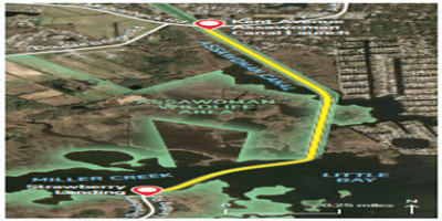
Kent Avenue Launch to Strawberry Landing
Local information
Fees & Parking: There is no parking fee for the Kent Avenue Assawoman Canal Launch. There is a daily park entry fee for Fenwick Island State Park (North). Costs vary for vehicles registered in Delaware and out-of-state. To avoid the daily fee, you can purchase an annual Delaware State Parks pass. Paddlers do not need a Conservation Access Pass to launch from Strawberry Landing, Sassafras Landing, or Mulberry Landing, which are all located in the Assawoman Wildlife Area.
Tides: The nearest tide tables are for Indian River Inlet.
Weather: Check the forecast for Bethany Beach, DE.
Trail Towns: South Bethany and Fenwick Island
eBird checklists: Assawoman Wildlife Area and Fenwick Island State Park
Paddlers’ notes: Be mindful of boat traffic and wind when paddling the open water of Little Assawoman Bay.
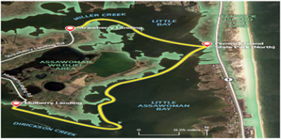
Strawberry Landing to the Assawoman Recreation Area of Fenwick Island State Park (North) to Mulberry Landing
Local information
Fees & Parking: There is no parking fee for the Kent Avenue Assawoman Canal Launch. There is a daily park entry fee for Fenwick Island State Park (North). Costs vary for vehicles registered in Delaware and out-of-state. To avoid the daily fee, you can purchase an annual Delaware State Parks pass. Paddlers do not need a Conservation Access Pass to launch from Strawberry Landing, Sassafras Landing, or Mulberry Landing, which are all located in the Assawoman Wildlife Area.
Tides: The nearest tide tables are for Indian River Inlet.
Weather: Check the forecast for Bethany Beach, DE.
Trail Towns: South Bethany and Fenwick Island
eBird checklists: Assawoman Wildlife Area and Fenwick Island State Park
Paddlers’ notes: Be mindful of boat traffic and wind when paddling the open water of Little Assawoman Bay.
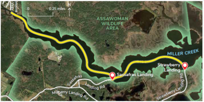
Miller Creek
Local information
Fees & Parking: There is no parking fee for the Kent Avenue Assawoman Canal Launch. There is a daily park entry fee for Fenwick Island State Park (North). Costs vary for vehicles registered in Delaware and out-of-state. To avoid the daily fee, you can purchase an annual Delaware State Parks pass. Paddlers do not need a Conservation Access Pass to launch from Strawberry Landing, Sassafras Landing, or Mulberry Landing, which are all located in the Assawoman Wildlife Area.
Tides: The nearest tide tables are for Indian River Inlet.
Weather: Check the forecast for Bethany Beach, DE.
Trail Towns: South Bethany and Fenwick Island
eBird checklists: Assawoman Wildlife Area and Fenwick Island State Park
Paddlers’ notes: Be mindful of boat traffic and wind when paddling the open water of Little Assawoman Bay.
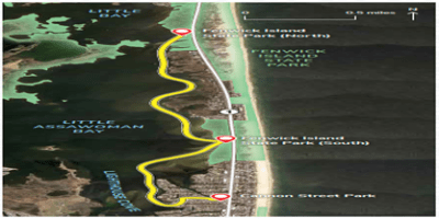
Assawoman Recreation Area of Fenwick Island State Park (North) to Cannon Street Park
Local information
Fees & Parking: There is a daily park entry fee for Fenwick Island State Park (North). Costs vary for vehicles registered in Delaware and out-of-state. To avoid the daily fee, you can purchase an annual Delaware State Parks pass. PLEASE NOTE: Fenwick Island State Park (South) prohibits the launch of personal boats. Coastal Kayak is the permitted outfitter for Fenwick Island State Park (South), and they offer rental kayaks, paddleboards, and sailboats. There is no fee to launch from Cannon Street Park.
Tides: The nearest tide tables are for Indian River Inlet.
Weather: Check the forecast for Bethany Beach, DE.
Trail Towns: South Bethany and Fenwick Island
eBird checklists: Assawoman Wildlife Area and Fenwick Island State Park
Paddlers’ notes: Be mindful of boat traffic and wind when paddling the open water of Little Assawoman Bay.
Seaford Canoe and Kayak Launch
Use: Canoes and kayaks only
Water: Tidal
Current: Minimal
Depth: Shallow at the launch. The launch can become inaccessible during extreme low tides and low water conditions.
Parking: Yes, limited gravel lot
Restrooms: No
Fees: No
Managed by: City of Seaford
Accessible: Yes, floating dock.
Boat Ramp or Pier: Hand carry launch with a floating dock.
Picnic Area: No
Swimming: No

Seaford Riverwalk
Use: Canoe, kayak launch, and passive recreation area.
Water: Tidal
Current: Moderate to Strong
Depth: Deep
Parking: No
Restrooms: No
Fees: No, A fishing license is required to fish.
Managed by: City of Seaford
Accessible: Yes, floating dock.
Boat Ramp or Pier: One (1) fishing pier and one (1) floating dock/launch.
Picnic Area: No
Swimming: No
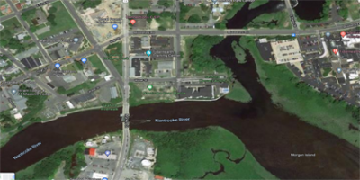
Seaford Boat Ramp
Use: Large motorboats, canoes, and kayaks
Water: Tidal
Current: Strong. Going against the current can make for a difficult paddle.
Depth: Deep. The launch is located on the mainstem of the Nanticoke River. The river is fairly wide at this location and windy conditions can make paddling difficult.
Parking: Yes, Large paved lot.
Restrooms: Seasonally
Fees: Motorboats must be registered in Delaware or have a valid ramp certificate (non-motor boats are exempt).
Managed by: Delaware Division of Fish and Wildlife
Accessible: Yes, floating docks.
Boat Ramp or Pier: Four (4) boat ramps, one (1) fishing pier.
Picnic Area: No, Neighboring Riverview Park has a picnic area and picnic pavilion.
Swimming: No
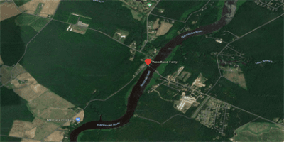
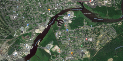
Woodland Wharf Kayak and Canoe Launch
Use: Kayaks and Canoes
Water: Tidal, fresh
Current: Strong, going against the current can make for a difficult paddle.
Depth: Deep, typically between 4 and 4.5 meters in depth.
Parking: Yes, gravel lot. There are also bike racks available.
Restrooms: No
Fees: No
Managed by: Delaware Division of Fish and Wildlife
Accessible: Yes
Boat Ramp or Pier: Kayak and canoe launch from dock.
Picnic Area: No
Swimming: No
Special Notes: The Woodland Wharf Kayak and Canoe Launch is located in close proximity to the Woodland Ferry. The current is quite strong in this portion of the river, please be aware of your surroundings and the ferry location when launching from this site. It may not be suitable to those who are new to kayaking or canoeing.
Laurel Kayak/Canoe Launch
Use: Canoes, kayaks, paddleboards
Water: Fresh
Current: Moderate. Tidal currents and wind
Depth: Moderate.
Parking: Yes. Gravel roadway with grass parking area.
Restrooms: No
Fees: No
Managed by: Town of Laurel
Accessible: Not at this time. Floating dock has a ramp, but the wooden dock structure is not accessible.
Boat Ramp or Pier: Yes. Launch is a floating dock with ladder and KayaArm stabilizer.
Picnic Area: No
Swimming: No
Roger C. Fisher Laurel River Park
Use: Motorboats, canoes, and kayaks
Water: Tidal
Current: Moderate to Strong. Going against the current can make for a difficult paddle.
Depth: Deep
Parking: Yes, paved lot.
Restrooms: Seasonally
Fees: Motorboats must be registered in Delaware or have a valid ramp certificate (non-motor boats are exempt). A fishing license is required to fish.
Managed by: Delaware Division of Fish and Wildlife
Accessible: Yes, floating dock.
Boat Ramp or Pier: One (1) boat ramp, one (1) fishing pier.
Picnic Area: Yes, picnic pavilion, picnic tables throughout.
Swimming: No
Special Notes: In addition to the boat ramp and fishing pier, the park also has a pubic playground, tot lot, swings and picnic pavilion managed by the Town of Laurel.
Edward Koch Access Area
Use: Canoe, kayak, fishing
Water: Tidal
Current: Moderate to Strong
Depth: Deep
Parking: Yes, limited
Restrooms: No
Fees: No, A fishing license is required to fish.
Managed by: Delaware Division of Fish and Wildlife
Accessible: No
Boat Ramp or Pier: No, hand carry only
Picnic Area: Yes, picnic table
Swimming: No
Phillips Landing
Use: Motorboats, canoes, and kayaks
Water: Tidal
Current: Strong. Going against the current can make for a difficult paddle.
Depth: Deep. The launch is located on the mainstem of Broad Creek.
Parking: Yes, large paved lot.
Restrooms: Seasonally
Fees: Motorboats must be registered in Delaware or have a valid ramp certificate (non-motor boats are exempt). A fishing license is required to fish.
Managed by: Delaware Division of Fish and Wildlife
Accessible: Yes, floating dock.
Boat Ramp or Pier: Three (3) boat ramps.
Picnic Area: Yes, picnic tables throughout.
Swimming: No
Special Notes: Bank fishing is permitted.
Modal title